Isole Egadi

Favignana
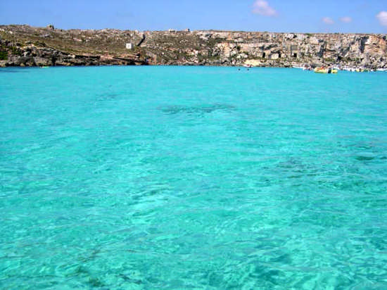
L'Isola di Favignana è la principale delle Isole Egadi; si trova a circa 7 km dalla costa occidentale della Sicilia, tra Trapani e Marsala, di fronte alle Isole dello Stagnone, che sono a loro volta di fronte all'aeroporto internazionale di Trapani "Birgi".
Ha una superficie di 19 km2 e uno sviluppo costiero di 33 km frastagliate e ricche di cavità e grotte. Anticamente il nome di Favignana era Aegusa termine che significa farfalla, data la forma dell'isola. Il nome attuale deriva dal Favonio che è un vento caldo di ponente che ne determina il clima molto mite. Nonostante nell'antichità fosse ricca di vegetazione, oggi ne è povera a causa del disboscamento. L'altitudine massima dell'isola è quella del Monte Santa Caterina, di 314 metri s.l.m. e una collina alta 252 metri. Sul lato meridionale si trovano gli isolotti Galera e Galeotta (praticamente degli scogli).
Favignana presenta alcune tracce preistoriche di insediamenti umani; è menzionata da Tucidide come sede di un insediamento fenicio. Vi si trovano i resti di un cimitero paleocristiano. Nel 1081 i Normanni vi realizzarono un villaggio e possenti fortificazioni, il forte San Giacomo e quello di Santa Caterina. Nel periodo angioino nacquero le due tonnare.
Nel 1874 l'isola appartenne ai Florio che ne potenziarono le tonnare e vi costruirono una villa in stile liberty. Favignana è famosa per le sue cave di tufo, per le grotte e per l'antica tradizione della pesca del tonno con la tonnara, di derivazione araba.
La tonnara di Favignana è una delle poche rimaste in attività in Italia, e ogni anno, nel mese di maggio, vi si svolge la Mattanza, la pesca dei tonni che attira molti turisti ed appassionati (anche il giudice Giovanni Falcone, quando fu ucciso, era sceso apposta da Roma in Sicilia per assistervi]).
Pur essendo abbastanza brulla l'isola offre oltre alla macchia mediterranea, costituita da Oleastro, Lentisco, Carrubo, Euforbia e Sommacco, anche delle specie endemiche: il cavolo marino (brassica macrocarpa), la finocchiella, la calendula marittima ed altre specie.
Marettimo
L'antico nome greco dell'isola, citato da Polibio, era Hierà Nésos, che significa "Isola Sacra". Il nome attuale deriva molto probabilmente da "Marìtima", nome latino dell'Isola che compare già nell' Itinerario Antonino del III secolo d.C. Alcuni studiosi suggeriscono che l'origine del nome sia da ricercare nell'abbondante presenza del timo selvatico. Questa non è tuttavia l'unica tipologia di erba che cresce spontaneamante nell'isola, il cui clima del tutto particolare ha contribuito allo sviluppo di una flora straordinaria.
Le antiche popolazioni di questa ristretta area del Mediterraneo (Fenici, Elimi, Sicani) le attribuirono il carattere di sacralità di cui ancora oggi si può godere. Secondo la teoria trapanese dell'Odissea, Marèttimo verrebbe a coincidere, dal punto di vista geografico, con Itaca, la patria di Ulisse. Sarebbe lo stesso eroe ad indicarne la posizione.
Diversi autori citano Hierà come il luogo dove venne firmato il trattato di pace tra Romani e Punici-Cartaginesi dopo la drammatica Battaglia delle Egadi del 10 marzo del 241 a.C., che vide Amilcare Barca e le proprie navi sconfitti dalle pentere e trireme dotate di rostri dei Romani comandati da Lutazio Catulo.
Il castello di Punta Troia, edificato in periodo normanno (circa 1140) sui resti di una preesistente torre di avvistamento, venne in seguito usato anche come carcere. Nel periodo borbonico all'interno delle sue anguste e buie celle fu detenuto anche Guglielmo Pepe.
A differenza delle restanti isole dell'arcipelago (Lèvanzo e Favignana), Marèttimo si è staccata dalla terraferma diverse migliaia di anni prima, sviluppando in tal modo antichi endemismi, come la Brassica Macrocarpa (Cavolo delle Egadi) e il Seseli Bocconi, pianta arbustiva che cresce sulle rupi attorno al Semaforo. Le guide internazionali la definiscono la perla del mediterraneo per il blu intenso e limpido delle sue acque. Le grotte, i fenomeni carsici, i ricchi fondali contribuiscono a definirne la bellezza.
Oggi Marèttimo fa parte della riserva naturale delle Egadi. Il villaggio di Marettimo, costruito secondo le tradizionali forme architettoniche mediterranee, è collegato con Trapani attraverso passaggio in aliscafo (un ora di navigazione) o traghetto (circa tre ore). Sull'isola, oltre a piccoli esercizi commerciali, una chiesa, e qualche locanda, è presente un telefono pubblico e una piccola ma fornita biblioteca storico-naturalistica presso Associazione "Marettimo", via Campi 3. Tel. 0923 923000. Il punto più alto dell'isola è il Monte Falcone (686 mt).
Levanzo
L'Isola di Lèvanzo è la più piccola delle Isole Égadi avendo una superficie emersa di appena 5 km quadrati. È costituita da rocce calcaree bianche che presentano numerose grotte. L'antico nome romano dell'isola era Phorbantia dal nome di una particolare spezia presente nella flora del posto.
Il paese è uno sparuto gruppo di case su un piccolo porticciolo che, come racconta un pescatore abitante dell'isola, non dà neanche ricovero alle imbarcazioni che sono trascinate via dal mare in un giorno di burrasca e dista circa 15 km da Trapani. È priva di strade rotabili, a parte un piccolo tratto di strada asfaltata che conduce alla spiaggia del Faraglione. Ciò più che uno svantaggio, è invece il miglior contributo per l'integrità della sua bellezza paesaggistica.
Il promontorio più alto è il pizzo Monaco, 270 m.s.l.m. Sulla costa si affacciano alcune grotte, la più nota è la Grotta del Genovese, dove due epoche preistoriche vivono parallele. Sono stati rinvenuti resti risalenti al mesolitico, circa 6.000 - 7000 a.C. e sulle pareti sono presenti interessanti manifestazioni di arte rupestre.

The island of Favignana is the main of the Egadi Islands; it is located about 7 km from the west coast of Sicily, between Trapani and Marsala, in front of the Stagnone Islands, which are in turn in front of Trapani "Birgi" international airport.
It has an area of 19 km2 and a coastline of 33 km jagged and rich in cavities and caves. In ancient times the name of Favignana was Aegusa, a term meaning butterfly, given the shape of the island. The current name derives from the Favonio which is a warm west wind that determines the very mild climate. Although in ancient times it was rich in vegetation, today it is poor due to the deforestation. The maximum altitude of the island is that of the Monte Santa Caterina, of 314 meters s.l.m. and a hill 252 meters high. On the southern side there are the Galera and Galeotta islands (practically of the rocks).
Favignana Favignana has some prehistoric traces of human settlements; it is mentioned by Tucidide as the site of a Phoenician settlement. There are the remains of an early Christian cemetery.
In 1081 the Normans built a village there and mighty fortifications, the Fort San Giacomo and that of Santa Caterina. In the Angevin period the two tonnare were born.
In 1874 the island belonged to the Florio family who strengthened the traps and built a liberty style villa there. Favignana is famous for its tufa quarries, caves and the ancient tradition of tuna fishing with the tonnara, of Arab derivation.
The tonnara of Favignana is one of the few remaining in activity in Italy, and every year, in the month of May, there is held the Mattanza, the tuna fishing that attracts many tourists and enthusiasts (even the judge Giovanni Falcone, when he was killed, had come down from Rome to Sicily to assist you]).
Despite being quite barren, the island offers, besides the Mediterranean scrub, consisting of Oleastro, Lentisco, Carrubo, Euforbia and Sommacco, also of the endemic species: the sea cabbage (brassica macrocarpa), the fennel, the maritime calendula and other species.
Marettimo
The ancient Greek name of the island, quoted by Polybius, was Hierà Nésos, which means "Sacred Island". The current name probably derives from "Marìtima", the Latin name of the island that already appears in the Antonine Itinerary of the 3rd century AD Some scholars suggest that the origin of the name is to be found in the abundant presence of wild thyme. However, this is not the only type of grass that grows spontaneously on the island, whose particular climate has contributed to the development of an extraordinary flora.
The ancient populations of this restricted area of the Mediterranean (Phoenicians, Elymians, Sicans) attributed it to the sacred character that can still be enjoyed today. According to the Trapani theory of the Odyssey, Marèttimo would coincide, from the geographical point of view, with Ithaca, the homeland of Ulysses. It would be the hero himself to indicate the position.
Several authors cite Hierà as the place where the peace treaty between the Romans and the Carthaginians was signed after the dramatic Battle of the Egadi of 10 March 241 BC, which saw Amilcare Barca and his ships defeated by the pentere and trireme equipped with rostrums of the Romans commanded by Lutatius Catulus.
The castle of Punta Troia, built in the Norman period (around 1140) on the ruins of an existing sighting tower, was later used also as a prison. In the Bourbon period, Guglielmo Pepe was also held inside his narrow and dark cells.
Unlike the remaining islands of the archipelago (Lèvanzo and Favignana), Marèttimo broke away from the mainland several thousand years earlier, thus developing ancient endemisms, such as the Brassica Macrocarpa (Cavolo delle Egadi) and the Seseli Bocconi, a shrub that grows on the cliffs around the Traffic Light. The international guides define it as the pearl of the Mediterranean due to the intense and clear blue of its waters. The caves, the karst phenomena, the rich depths contribute to define its beauty.
Today Marèttimo is part of the Egadi nature reserve. The village of Marettimo, built according to traditional Mediterranean architectural forms, is connected with Trapani by hydrofoil (one hour navigation) or ferry (about three hours). On the island, in addition to small shops, a church, and some inns, there is a public telephone and a small but well-stocked historical-naturalistic library at the "Marettimo" Association, via Campi 3. Tel. 0923 923000. The highest point the island is the Monte Falcone (686 mt).
Levanzo
Lèvanzo Island is the smallest of the Égadi Islands having a surface area of just 5 square km. It consists of white limestone rocks that have numerous caves. The ancient Roman name of the island was Phorbantia from the name of a particular spice present in the flora of the place.
The village is a small group of houses on a small port.